New Paltz
Ulster County,
New York
Total Time: 2:45 hr
Estimated Distance: 4.7 miles
Level of Difficulty: Difficult (Tight scrambles and climbs)
Level of Interest: Highly Recommended; one of the best hikes.
Points Of Interest: Outstanding scrambles and caves, panoramic view
Trails:
Huegenot Trail
Bonticou Carriageway
Rock Rift Trail
Lookout Carriageway
Whitney Path
Tallman Path
Pinkster Path
Mohonk Path
Sky Top Carriageway
Sky Top Path
Lake Shore Carriageway
Fox Path
Glen Anna Path
North Lookout Carriageway
Whitney Carriageway
Hiking Partner:
Sruli Rosenberg
Google Map of Parking:
View Hiking Blog Localities in a larger map
Mohonk is situation on one of the prettiest parcels of land in the Northeast. Its beautiful mountains, vistas, white rocks, and fantastic scrambles really make this a unique place. However, it is not a state park but rather privately owned. The price to get in is outrageous ($25 per person) but still worth it. The crowds in the main area by the hotel are also a distraction from the serenity, especially during the weekends. However, the scrambles and views are top notch and still make this one of the most outstanding hiking destinations.
One of the biggest challenges for hikers at Mohonk is that there are so many Carriage Roads and trails, and not all are clearly labelled and go where you want them to go. But there is an excellent number of choices a to choose from.
We parked at the entrance to Mohonk at Mountain Rest Road, and took the Huegenot Trail east. From there we cut accross and bushwacked down the really steep hill to the Bonticou Carriageway, which we then took the Rock Rift Crevices. The Rock Rift Crevices provide a trail going through an outstanding scramble inside caves and tunnels, and is very challenging yet rewarding, and surprisingly not well-known.
After coming out the crevices we headed up the mountain to the Lookout Carriageway, which had great views facing north and east, and then Whitney Path to the Tallman Path, and then the Pinkster Path to the Mohonk Path, which climbed Sky Top. From there we took the Sky Top Carriageway to the tower at Sky Top, and then attempted to go down the Labyrinth but it is a one way trail the other way, so we just cut across a shortcut scramble down to Lake Mohonk at the Lake Shore Carriageway. From there we walked along the Mohonk Lawn and Botanical Garden until the Bruin Path, which has some nice scenery of cliff walls, and then headed back via the Fox Path to the Glen Anna Path, and then to the North Lookout Carriageway, Whitney Carriageway, and then to the Huegenot Path.
 |
| Map of the Route |
 |
| Sruli at the beginning of the Rock Rift Crevices |
 |
| Sruli Navigating Thru a Crevice |
 |
| Me in Rock Rift Crevice |
 |
| Inside a Passageway in Rock Rift Crevices |
 |
| Squeezing my way through. This is NOT a hike for fat people! |
 |
| I can barely fit in here! Rock Rift Crevices. |
 |
| Nearing the End of Rock Rift Crevices. |
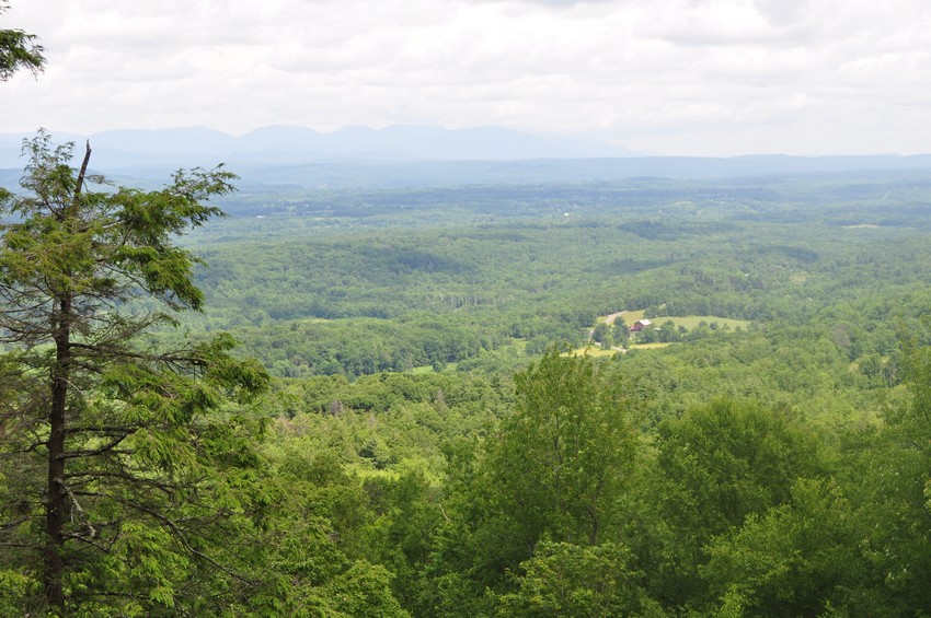 |
| A viewpoint along the "Lookout Carriageway". Facing north. |
 |
| Sruli in a Gazebo on the Lookout Path above the cliff. |
 |
| Mohonk Mountain House from the end of the Tallman Path. Facing east. |
 |
| View from Sky Top. Facing southeast towards Storm King and Beacon Mnt. |
 |
| View of the Trapps from Sky Top. This cliff is the most popular rock climbing cliff in the northeast. |
 |
| Sruli with the Trapps in the Background. |
 |
| View of Eagle Cliff from Sky Top. Facing southwest. |
 |
| The Smiley Tower atop Sky Top with Sruli posing from above. |
 |
| The Mohonk Mountain House with Mohonk Lake. From Sky Top. With Catskill Mountains in background. This is a famous picture. |
No comments:
Post a Comment