Sunday, August 25, 2013

Major Welch/AT Bear Mountain Loop

Bear Mountain State Park
Rockland and Orange Counties,
New York

Hiking Trails:

Major Welch Trail: Red blaze
Appalachian Trail: White blaze
AT Connector Trail: Blue blaze

Total Time: 2:45 hours
Estimated Distance: 5.1 miles
Level of Difficulty: Difficult
Level of Recommendation: Recommended
Points Of Interest: Hessian Lake, Major Welch Scramble, Bear Mountain Summit 
Pros: Good climb, dramatic views
Cons: Not quiet and remote

Hiking Partner:
Michael Wander

Google Map of Parking:

View 2013 Hiking Locations in a larger map

I had not been up the Major Welch Trail in a while, and they had recently done some trail rerouting so I wanted to check out the new changes. We parked at the Hudson River Landing, down off Route 9W, where parking is free. This area had been closed for reservations for the past year or so, so I was glad that they had opened it. We climbed up the path near the zoo, where it meets the combined Appalachian Trail and 1777E Trail. We took the tunnel under Route 9W, and walked on the path on the east side of Hessian Lake around the lake to where the Major Welch joins up with the trail. The entire bottom part of the Major Welch prior to the rock scramble has been refurbished or rerouted. Rock steps have also been built in parts of this area. We continued up along the scramble to the famous view of the Bear Mountain Bridge, and then continued up to the summit.

Once at the top we took one of the short connector trails off the Major Welch back to the Appalachian. We climbed up the Observation Tower, and then took the Appalachian Trail down on the new part of the trail. At the bottom we took the short connector trail along the east side of the lake and then back through the tunnel and back to our cars.

Map of the Route.
Harriman/Bear Mountain State Parks - Northern Map

Hessian Lake, with Bear Mountain Looming Behind

Sign at the Beginning of the Major Welch Trail

Newly Configured Steps Ascending the Major Welch

Michael Ascending the Large Rocks on the Major Welch Ascent

Major Welch View of the Hudson River.
Facing Northeast.

Major Welch View Facing North.

Major Welch View Facing North,
with the Hudson River, Fort Montgomery, and Brooks Lake in View

Michael At the Major Welch View.
Facing East Towards Anthony's Nose

Major Welch  View of the Bear Mountain Bridge. Facing East.

Me at the Major Welch View, Facing Northeast.

Popolopen From the Major Welch View. Facing Northwest.

Michael in the Observation Tower, Facing South Toward Dunderberg

View of the Motorcyclists and Viewpoint From the Tower

View Facing South from the Viewpoint.
Facing South to West Mountain and The Timp

Zoomed in View Above, with the Manhattan Skyline in the Distance

Me at the Bear Mountain Main View

Michael at the Bear Mountain Main View

View Descending  the Appalachian - Iona Island and Peekskill

Sunday, August 18, 2013

Johnstown Road to Big Hill

Harriman State Park
Rockland County,
New York

Hiking Trails:

Johnstown Road Connector Trail: Unblazed
Long Path: Green blaze
Old Turnpike: Unblazed

Total Time: 1:30 hours
Estimated Distance: 3.3 miles
Level of Difficulty: Moderate
Level of Recommendation: Recommended
Points Of Interest: Big Hill View 
Pros: Very remote area of park, nice view
Cons: Hike likes thrill

Google Map of Parking:

View 2013 Hiking Locations in a larger map

Big Hill is a nice view with a good climb, and a shelter on top. I have been here before but never taken this route nor this short stretch of the Long Path. I parked on Johnstown Road about 500 feet from the old Cemetery, and took the short Connector Trail which connects to the Long Path. I then took the Long Path until Big Hill, where it climbs up the Mountain. The Long Path route up Big Hill is much less exciting and not as dramatic as the other route up where the trail is combined with the Suffern-Bear Mountain Trail. I came down that Route, and then went along the Old Turnpike, which follows closely parallel to to the Long Path, and then at the intersection with the Camp Road took the Long Path back to the Connector Trail and back to my car.

Map of the Route.
Harriman/Bear Mountain State Park Southern Map

Large Wooden Bridge Across Swamp Outlet on the Long Path

Looking Into the Swamp From the Bridge

The Other Side of the Bridge

Shelter Atop Big Hill

View from Big Hill.
Facing East Towards Horse Chock Mountain

View from Big Hill, Facing Southeast.
The NYC Skyline was Faintly Visible in the Distance.

Confluence of the Long Path And Suffern-Bear Mnt Trail Atop Big Hill

Jackie Jones Tower in View While Ascending Big Hill

Thursday, August 15, 2013

Watkins Glen Hike, Part 2

Watkins Glen State Park
Schuyler County,
New York

Hiking Trails:

Couch's Staircase
Gorge Trail
Indian Trail
Lover's Lane

Total Time: 1:30 hours
Estimated Distance: 3.5 miles (approximately)
Level of Difficulty: Moderate

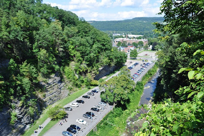
Since we were camping at Watkins Glen, I figured I should do one more hike here. I had some extra time, and took the opportunity to do a quick loop hike in the opposite direction. I started at the south entrance area, took the path to the Couch Staircase, which I took down to the Gorge Trail. I hiked the length of the Gorge Trail all the way to the end, and then took the Indian Trail above the north rim of the Gorge back down. I  took it to the suspension bridge, then took Lover's Lane down back to the Gorge under the bridge, and then back up at the Point Lookout. From there I crossed over the Suspension Bridge high atop the Gorge, and headed back through the Lily Pond and up the steps to the parking area.

Map of the Route.
Its a Bit Confusing to Follow Since I Repeat Some of the Trail by the Bridge
and then go over the Trail on the Bridge as Well.

Main Parking Area Near the Village.
Above Couch's Staircase Descent.

Cavern Cascade

Me Behind Cavern Cascade

Rainbow Falls

Lookout Along the Indian Trail

Cemetery Right Along  the Indian Trail

View From Lover's Lane

Lover's Lane Spur was Built in 1908!

Suspension Bridge

View of Couch's Staircase from the Point Lookout

Looking Down into the Gorge from the Suspension Bridge

Monday, August 12, 2013

Watkins Glen Hike, Part 1

Watkins Glen State Park
Schuyler County,
New York

Hiking Trails:

Gorge Trail: Unblazed

Total Time: 1:15 hours (with small children)
Estimated Distance: 1.5 miles (approximately)
Level of Difficulty: Easy (going down), but slippery where wet
Level of Recommendation: Highly Recommended
Points Of Interest: Deep gorge with beautiful scenery and waterfalls
Pros: Amazing experience and waterfalls, camping area on site
Cons: Trail very commercialized, very busy and crowded with hundreds of people

Hiking Partners:
My wife and children

Watkins Glen is a well-known scenic gorge in the Finger Lakes Region in Upstate New York. My family and I took a camping trip here, pitching a tent and spending the week here at Watkins Glen State Park. Of course the first day that we were here we hiked the gorge. Being that I have a small child and carried a baby on my back, we decided to start at the top and hike down towards the bottom, to make it easy for all parties present. This is definitely the wise way to do this hike, especially with small children. Thankfully we made it all the way to the end.

We parked the car at the upper entrance to Watkins Glen off Route 409. This is a very quiet area of the park and has nice facilities such as a playground and snack shop. It is at an elevation of 1,002 feet. We hiked down the Gorge Trail, which starts here, and went down the many steps at "Jacob's Ladder" down to the brook. This part of the brook has the trail right next to the water, and it is much quieter than further down the trail. After the Mile Point Bridge it gets much busier with many more people. We continued along the Gorge Trail all the way to the end, passing many named veiwpoints along the way such as the Spiral Gorge, Rainbow Falls, Central Cascade, Glen Cathedral, and the Narrows. Near the end is the Cavern Cascade, which is a very impressive waterfalls with a tall drop that you can go right behind.

The bottom of the hike opens up to a parking area which is right by the Village of Watkins Glen, about a block or two from Main Street. The elevation at the bottom entrance is 479 feet. There is a shuttle back up to the Upper Entrance which runs every 15 minutes, and we took this shuttle back up, where we enjoyed a picnic lunch back at the top.

Map of the Route

The Beginning of the Gorge Trail, as it Starts it Descent at "Jacob's Ladder"

The Relatively Quieter Upper Part of the Glen

The Brook Going Through a Narrow Crevice,
Taken from the Mile Point Bridge

Descending Through the Gorge

I Think this is Called the Spiral Gorge

Rainbow Falls, a Small, Drippy Waterfall That you can Walk Behind

Behind Rainbow Falls

Central Cascade, a High and Narrow Waterfall

This area is called "The Narrows"

The Top of the Cavern Cascade, where the Trail Goes Behind the Waterfalls

Full View of the Central Cascade

Small Waterfall Near the Entrance,
with the Cavern Cascades Behind.