Sunday, July 28, 2019

Dickie Barre in the Gunks

Minnewaska State Park,
Ulster Co.
New York

Hiking Trails:
Red Loop Trail: Red blaze
Peters Kill Trail: Yellow blaze
High Peters Kill Trail: Blue blaze
Bull Wheel Trail: White blaze

Total Time: 2:00 hour
Estimated Distance: 2.7 Miles

Pros: Beatiful area with great views and interesting terrain
Cons: None

Hiking Partners:
Jacob Baldinger
Yehudah Koblick
Shimmy Rosenberg

I have not had the opportunity to hike in the Shawangunks much this season, and was glad to finally get out on this nice summer day with some of my good friends and old hiking partners. We parked at the northern area of the park and took the Red Loop Trail down to the Peters Kill, and walked along the side of the creek to the Peters Kill Trail, which we took to the High Peters Kill Trail.

We took the High Peters Kill Trail up the mountain, to the view, and then continued to the view at Dickie Barre. We then turned around and took the Bull Wheel Trail back to the beginning of the hike to the Red Loop and then back to the parking area.


Map of the Route

Information Plaque at the Beginning of the Hike

Rock Climbers at the Beginning of the Hike

Peters Kill

Me at the Peters Kill

Jacob Ascending the Trail

View Ascending the High Peters Kill Trail

Me at the High Peters Kill Trail

View from the High Peters Kill Trail

Me Further out on the High Peters Kill Trail View

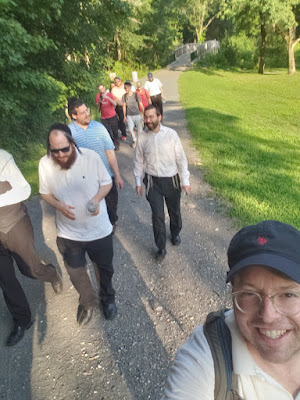
Our Extended Group

View of Mohonk from Dickie Barre

View of the Gap from Dickie Barre

Me at Dickie Barre

Thursday, July 25, 2019

Kakiat LinkedIn Hike

Kakiat County Park/
Harriman State Park
Rockland Co.,
New York

Hiking Trails:
Mountain Trail: Orange blaze

Total Time: 1:30 minutes
Estimated Distance: 1.7 miles

Pros: Good climb with nice views
Cons: None

Hiking Partner:
Many of my LinkedIn business contacts, including Brian Wallace, Shimon Rosenberg, Jacob Busani, and Jacob Engel

I have a nice group of LinkedIn business contacts, and decided to try something interesting and make a LinkedIn Local on the a mountain. So I organized a short hike up Kakiat with some amazing LinkedIn contacts. We parked at the Kakiat Park parking area after work about 2 hours prior to sunset, and climbed the mountain up the Mountain Trail to the first view at Kakiat Mountain. We had a LinkedIn discussion and Q&A at the first summit, and then the more serious hikers of the group ascended to the upper Kakiat summit. We then turned around and headed back down along the same trail, and met at the bottom for some more networking and group discussion.

Map of the Route

Me at the Trailhead Parking

Our Group Starting the Hike

First View Atop the Mountain

Above the Kakiat First Summit

Atop Kakiat First Summit, Looking Southeast

LinkedIn Local atop the Mountain

Group Photo atop Kakiat, with Brian Wallace in the Center

Atop the Rock on the Upper Kakiat Summit

The Group that Climbed to the Upper Kakiat Summit

Kakiat Upper Summit Sunset

View Towards the NYC Skyline from the Upper Summit

Picnic and Refreshments after the Hike

Sunday, July 14, 2019

Black Rock Mountain Loop

Harriman State Park,
Orange Co.
New York

Hiking Trails:
Ramapo-Dunderberg Trail: Red blaze
Dunning Trail: Yellow blaze
White Bar Trail: White blaze

Total Time: 2:00 hour
Estimated Distance: 3.5 Miles

Pros: Very scenic area and good climb, with great views and blueberries
Cons: Lacking shade

Hiking Partners:
Jacob Baldinger
Josef Friedman

This was another hot July day. I had the privilege of hiking with Jacob Baldinger, and friend from my youth who I'd go hiking with fairly frequently.

Unfortunately, I had left my camera SD card in my computer, and only noticed after the hike was complete. All my photos on this hike are lost. I just have a few that I snapped from my cell phone and photos that Jacob sent me.

We parked on Lake Kanawauke Road at the Ramapo Dunderberg Trail, and took the Ramapo Dunderberg Trail up to the Black Rock View. We continued along the ridge, with a great bounty of blueberries along the sunny area, and then descended the mountain on the Dunning Trail. We took the Dunning Trail to the White Bar Trail to the trailhead parking area on Lake Kanawauke Road, where we had our second car.

Map of the Route

Me on Black Rock Rock Mountain

Me on Black Rock Mountain

Me and Jacob on Black Rock Mountain

Blueberry Harvest

Jacob on Black Rock Mountain

Sunday, July 7, 2019

Cylburn Arboretum Hiking Trails

Cylburn Arboretum,
Baltimore
Maryland

Hiking Trails:
Woodlands Trail
Ridge Trail
Azalea Trail
Circle Trail
Etta Stem Wedge Trail
Spicebush Trail
Ravine Trail

Total Time: 1:00 hour
Estimated Distance: 2.3 Miles

Pros: Scenic area within city limits
Cons: Lack of views

I was in Baltimore visiting family for the weekend, and went out early Sunday morning for a quick hike. While there aren't any mountains in the area, there are some nice parks with trails, including Cylburn Arboretum which lies within the northern part of the city limits.

Cylburn Arboretum is a 200 acre park with an old historic mansion that has been preserved, with beautiful grounds and a botanical garden. There are several trails in the area that go through the woodlands. The mansion and gardens are surrounded by a deer fence to keep the deer out and protect the plants and flowers, so you have to go through the deer fence several times. I covered most of the hiking trails in the park, going from one end of the park to the other.

It was a very hot and muggy day, with temperatures in the 90's. I parked in the main parking area, and walked towards the mansion and gardens. I then went the trailhead area past the main gardens and took the Woodlands Trail down towards the valley to its terminus where the old tran station once was.

I then went back and took the short Ridge Trail to the Azalea Trail, to the Circle Trail and then the Etta Stem Wedge Trail. I then took the new Spicebush Trail to the Ravine Trail, which I took back up the ravine to the Circle Trail and to the Volmer Center. I then went back to my car from there.

Map of the Route

Large Tree Meadow Before the Hike

Approaching the Mansion 

A View of the Mansion

Botanical Gardens

Start of the Hiking Trails. Woodlands Trail is to the Left.

Deer Fence Door

One Tree Growing inside Another

Etta Stem Wedge Trail

Map at the End of the Hike