Rockland County,
New York
Total Time: 1:40 hr
Estimated Distance: 2.2 miles
Hiking Trails:
Mountain Trail: orange blaze
Kakiat Trail: white blaze
Hiking Parter:
Shimmy Rosenberg
Google Map of Parking:
View Hiking Blog Localities in a larger map
Hurricane Irene was not the monster they thought it would be, and it hit the area as a powerful tropical storm instead of a full-blown hurricane. However, the amount of rain it dropped on the area was absolutely incredible, with an excess of 11 inches in about a 12 hour period. The flooding in the area was historical and catastrophic, with many roads and bridges washed away.
The rain had ended and the sun was peeking through the cloud cover, and the winds had died down so we thought it was safe to venture out to a nearby hike. Actually we should have taken the warning signs to stay put as almost all the roads to get to there were closed by downed trees or downed power lines. I didn't quite realize just how bad things were until stepping out and heading for the hike. We eventually got to Kakiat, and noticed there was no way to get in - the Mahwah River had entirely flooded the area as well as the entrance and parking area to Kakiat. Not wanting to miss out, I drive to a more obscure entrance at West Gate Road through the back route. The road there was also flooded but still passable.
I parked the car and we proceeded to venture in, but a large tree was blocking the entrance and there was a full stream flowing on the path. I was wearing boots so was able to go into the flood stream and over the fallen tree. We took some views of the area entirely flooded and stood in disbelief at the speed and force that the river was flowing. The entire area was under water, and some parts were simply washed away, including the new foot road they built from the park entrance. We proceeded to climb the mountain, and for almost the entire way up the path was a flowing stream and waterfall. We finally got to the top, took some pictures of Manhattan which were clearly viewable under the gray cloud cover, and then proceeded our way down. As we were on our way back, the winds started picking up and then became very intense. The gusts started blowing severely and we were getting really scared as branches were starting to fall all over the place. We picked up speed and ran back to the refuge of our car.
I had mistakenly thought that once the rain ended and the sun came out that the storm was over. But we were in for a surprise with the howling winds that picked up afterwards. Had we known about this we would never have ventured out. I am glad we made it back and able to write this in the blog.
 |
| Map of the Route. I forgot to include the detour of the gas line path and the Kakiat Trail at the bottom of the mountain. |
 |
| The Kings Gate Entrance to Kakiat. Note the downed tree and stream on the path. |
 |
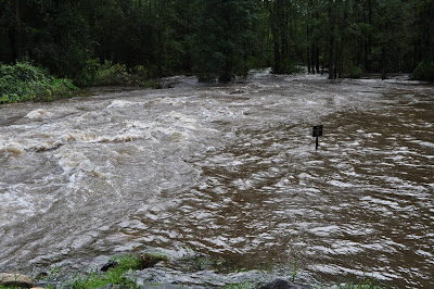
| The Mahwah River way over its banks. Note the park benches underwater. |
 |
| The Overflowing Mahwah River near the new bridge. Ironically that sign in the water says "No Swimming". |
 |
| The road totally overflowing and washed away. I am standing on the bridge over the river - all this ahead is supposed to be dry. |
 |
| The beginning of the orange trail. Much of the trail looked this way with fallen branches strewn about. |
 |
| The orange Mountain Trail is one big waterfall all the way down. |
 |
| The Manhattan Skyline in the Distance from the top of Kakiat |
 |
| The flooded Kakiat Trail |
 |
| Parks Department Crew replacing the washed out path. This photo was taken several days later when they were replacing the washed out road. |
No comments:
Post a Comment