Friday, February 24, 2012

Ein Bokek

Dead Sea Area,
Israel

Trails:

Ein Bokek Trail: Red blaze

I had traveled to Israel on a short vacation, and was staying in a hotel in the Ein Boken area. Ein Bokek is located in the southern end of the Dead Sea, and also all of Dead Sea Hotels and spas are in this area. The area is named after a small oasis on the mountainside in this dry, parched terrain. The climb to the oasis is a relatively short climb from the road and the hotel area, and was literally right outside from the hotel which we were staying at. We only climbed up to the oasis, though the trail continues for much longer up the mountain. We came down the same path. 

Looking towards the spring and the mountain - Har Bokek

Ancient Ruin near the beginning of the hike.

Approaching towards the oasis.


At the dense brush in the oasis.


Me with Har Bokek in background.
Me on the desolate mineral formations.
Me again.

Sunday, February 19, 2012

Black Rock Mountain

Harriman State Park
Orange County, NY

Trails:
Ramapo Dunderberg Trail: Red blaze

Dunning Trail: Yellow blaze
Nurian Trail: White blaze

Total Time: 2 hour
Estimated Distance: 3.88 Miles
Level of Difficulty: Difficult
Level of Recommendation: Highly Recommended
Points Of Interest: Amazing Scenery and views, good climb


Google Maps of Parking:

View 2012 Winter in a larger map

This is one of my favorite hikes in Harriman! The scenery and terrain is incredible and the climb is also excellent. I I parked on the trailhead on Lake Kanawauke Rd (County Route 106 - the same trailhead as last week's hike) and went north on the Ramapo Dunderberg Trail snaking up Black Rock Mountain. There is a beautiful view up on the top here. Once at the top continued along the Ramapo Dunderberg Trail through the interesting scenery or large bedrock exposures and stunted trees. From there headed west on the Dunning Trail, down past Surebridge Mountain, and then to the Nurian Trail. Took the Nurian Trail south, continuing alongs its combination with the White Bar Trail, and then back up Black Rock Mountain and down again back to the car.

Map of the Route

View Near the top of Black Rock Mountain.
Facing east towards Jackie Jones.

View from Black Rock near view.
Facing south looking at Tom Jones Mountain.

View from Black Rock facing southwest.

Hikers atop Black Rock, at the R-D and Nurian Trail crossing.

Black Rock.

Another view at Black Rock. Facing west.

View continuing north atop Black Rock.
Facing northwest.

Another view continuing north.
Facing northwest, with Schunnemunk in the distance.

Ascending the treeless true summit of Black Rock Mnt.

Sunday, February 12, 2012

Parker Cabin Mountain

Harriman State Park
Orange County, NY

Trails:

Victory Trail: Blue blaze
Ramapo Dunderberg Trail: Red blaze
White Bar Trail: White blaze
Triangle Trail: Yellow blaze

Total Time: 1:30 hour
Estimated Distance: 3.1 Miles
Level of Difficulty: Slightly Difficult
Level of Recommendation: Recommended
Points Of Interest: Good views, tranquil

Google Maps of Parking:

View 2012 Winter in a larger map


It was different being back to the east coast after my trip to Arizona. It was a nice winter day in New York, where I hiked this relatively short and tranquil hike. I parked on the trailhead on Lake Kanawauke Rd (County Route 106) and took the Victory Trail for a short distance to the intersection of the Ramapo Dunderberg Trail. I headed south on the Ramapo Dunderberg slowly climbing Parker Cabin Mountain, where there are two very nice views here. From there headed down the mountain to the White Bar Trail, which i took to the Triangle Trail, and then back to the Ramapo-Dunderberg and Victory for the return.

Map of the Route


Staring the Ascent on Parker Cabin Mountain


View on Parker Cabin Mountain.
Facing southeast overlooking Lake Skenonto and Lake Sebago

View from Parker Cabin Mountain.
Facing East towards Jackie Jones Mountain

View from the south lookout at Parker Cabin Mountain.
Facing South.

Another view from the south lookout.
Facing southwest.

Descending Parker Cabin Mountain near the end of the hike.
Looking towards Tom Jones Mountain, facing northeast.

Monday, February 6, 2012

Pima Canyon

Santa Catalina Mountains,
Near Tucson
Pima County,
Arizona


Trails:
Pima Canyon Trail

Total Time:
1:25 hrs
Estimated Distance: 2.4 miles
Level of Difficulty: Very Easy
Level of Recommendation: Highly recommended
Points Of Interest: Beautiful desert and canyon views

I was in Tucson, Arizona, on a business trip, and took off about an hour and a half to take a relatively short but scenic hike through the beautiful mountains north of Tucson. Pima Canyon is in the Coronado National Forest, in the same mountain range as Mount Lemmon in the Santa Catalina Mountains. It is very similar in nature to the nearby and famous Sabino Canyon, but is much more quiet and tranquil. The scenery is breathtaking, with continuous beautiful views, while surrounded by towering saguaros
 and a lush desert vegetation. This desert is unique in that it is dense with strange plants and cacti and is surprisingly lush for a desert. The Trailhead for Pima Canyon is on E. Magee Road in North Tucson. I took the trail for about 1.2 miles before turning back on the same route.


Map of the Route.
 
Near the beginning of the hike, facing Pima Canyon.

Lush desert vegetation.

Dense Saguaro Grove

Entering into the canyon
 
Floor of the canyon. It was dried out.

Heading back. Downtown Tucson is in the distance.

Interesting Saguaro Shot

Another view of the dense cactus grove

Tunnel underneath the road at the beginning of the hike.

Sunday, February 5, 2012

Camelback Mountain

Phoenix
Maricopa County,
Arizona


Trails:
Echo Canyon Trail
Cholla Trail

Total Time: 2:30 hrs
Estimated Distance: 4.2 miles (including walk on road to trailhead)
Level of Difficulty: Difficult
Level of Recommendation: Highly recommended, though very busy
Points Of Interest: Excellent climb with odd formations and great views

I had traveled to Arizona for the week, and was staying in Scottsdale on Sunday, nearby Camelback Mountain. The last time I was staying in the Phoenix area, I was determined to hike Camelback on my next trip, and this was my opportunity. Camelback Mountain is the most prominent mountain in Phoenix, and it's a rugged hump right in the middle of the city.

There are two trails that climb the mountain to the summit: The Echo Canyon Trail on the west, and the Cholla Trail on the east. I started at the Echo Canyon Trail. Parking here is a nightmare - especially on a Sunday in the winter. The parking lot is tiny considering the volume of people. The only option if the parking area is to park about a mile a way and walk over, or take a shuttle which I was unable to find. So I parked all the way down, and walked all the way down the road to the trailhead. I took the Echo Canyon all the way up, and then continued past the summit to the Cholla Trail all the way down, for a full Camelback experience. I was able to get a rid at the bottom back at my car.

Map of the Route

At the beginning of the hike

Caves in the sandstone,
with some Saguaros, near the beginning of the hike.

Continuing the climb.

The steep climbing scramble part.

Continuing the Ascent

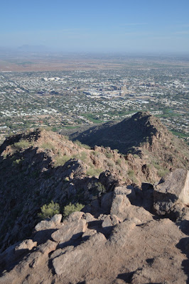
View facing downtown.
Facing South.

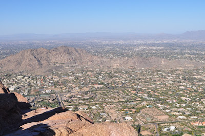
Mummy Mountain and Paradise Valley.
Facing northwest.

View from the summit.
Facing southeast towards Scottsdale.

Me at the Summit.

View north from the Summit, with Mummy Mnt.

View from summit facing northeast.

Vertical Cliff right below the summit.
Note the person on the top left.

View towards Downtown Scottsdale on the Descent.